
SteveJackson
Moderator & Supporting Member
Site: Mammoth, Utah
County, State: Juab, Utah
Years of Occupation: 1870-present
Status of Site: Open
Classification: Class 4 - Semi-Abandoned Town
Type: Mining
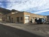
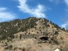
Remnants: Many buildings, foundations, active mine at the top of the
canyon
GPS Coordinates: 39.926232 -112.126924
NRHP Reference #: 79003468 http://focus.nps.gov/AssetDetail/NRIS/79003468
Date of Last Visit: 11/26/2016
Mammoth was established in 1870 and was expected to be a huge mine (hence the name). In 1873, the owners were growing weary of the investment costs and sold a majority stake in the mine to a pair of cattle ranching brothers from Texas. After a little more investment from the brothers, the mine finally struck it rich with gold, silver, lead, copper and bismuth.
At the highpoint in the 1910's the town had over 3,000 residents. Mammoth had a lumber yard, daily coach service to Eureka, billiard hall, bookstore, chinese laundry, school, post office and four hotels.
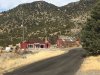
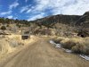
Today, some people still live in the old town. And a mining operation is still active at the top of the canyon, please respect their requests to avoid trespassing.
The lower part of the town is also referred to as Robinson. The name came from GH Robinson, an engineer for the mine who was in charge of the Sioux mill at the bottom of the canyon. Robinson was known as an eccentric and was finally fired from the mine after chartering a full train to take him to Salt Lake City for business.
Further Reading:
The Historical Guide to Utah Ghost Towns by Dr Stephen Carr
https://www.amazon.com/Historical-Guide-Utah-Ghost-Towns/dp/091474030X
Directions to Get There:
Follow Hwy 6/50 3 miles west/south of Eureka, the road to Mammoth is on the left and is well marked.
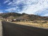
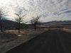
Modern Pictures:
County, State: Juab, Utah
Years of Occupation: 1870-present
Status of Site: Open
Classification: Class 4 - Semi-Abandoned Town
Type: Mining
Remnants: Many buildings, foundations, active mine at the top of the
canyon
GPS Coordinates: 39.926232 -112.126924
NRHP Reference #: 79003468 http://focus.nps.gov/AssetDetail/NRIS/79003468
Date of Last Visit: 11/26/2016
Mammoth was established in 1870 and was expected to be a huge mine (hence the name). In 1873, the owners were growing weary of the investment costs and sold a majority stake in the mine to a pair of cattle ranching brothers from Texas. After a little more investment from the brothers, the mine finally struck it rich with gold, silver, lead, copper and bismuth.
At the highpoint in the 1910's the town had over 3,000 residents. Mammoth had a lumber yard, daily coach service to Eureka, billiard hall, bookstore, chinese laundry, school, post office and four hotels.
Today, some people still live in the old town. And a mining operation is still active at the top of the canyon, please respect their requests to avoid trespassing.
The lower part of the town is also referred to as Robinson. The name came from GH Robinson, an engineer for the mine who was in charge of the Sioux mill at the bottom of the canyon. Robinson was known as an eccentric and was finally fired from the mine after chartering a full train to take him to Salt Lake City for business.
Further Reading:
The Historical Guide to Utah Ghost Towns by Dr Stephen Carr
https://www.amazon.com/Historical-Guide-Utah-Ghost-Towns/dp/091474030X
Directions to Get There:
Follow Hwy 6/50 3 miles west/south of Eureka, the road to Mammoth is on the left and is well marked.
Modern Pictures:
Attachments
Last edited: