lordhelmet
Member
Site: Kosmo, Utah
County, Box Elder, Utah
Years of Occupation: 1901 - ? Perhaps someone else knows?
Status of Site: Open
Classification: Class 1,
Type: Mining - Railroad spur
Remnants: Foundations
GPS Coordinates: N41.71772 W112.79149
NRHP Reference #: N/A
Date of Last Visit: 10/14/17
Kosmo sometimes spelled Cosmo was built in two parts, the east part was built in 1901 as a rail spur for the growing number of ranchers in the area. The west part, (about a half mile away) was built in 1912 as a spur for Potash mining. Both areas were serviced by the Transcontinental rail line.
At that time potash was used in the manufacture of gun powder. Prior to this time most potash came from Germany but with the approach of world war 1, potash became difficult to acquire. Mining pot ash from the Great Salt Lake proved to be very profitable and west Kosmo was born. Around 1924 over 200 people lived in Kosmo.
The town contained 3 bunk houses, a cook house, garages, a General Store, a Blacksmith Shop, and several coal houses. Today not much remains, a few foundations, what appears to have been some type of loading dock and if you look southward you can still see some of the dykes and canals that were used.
Directions to Get There:
Take the most north Brigham City exit and head west past Corrine, toward ATK, (used to be Thiokol), turn toward the Golden spike monument museum. When you get to the last turn for the Museum, do not turn, head west several miles. There is not a sign for the town location, you best bet is to have a GPS. The town was/is located on the north/east end of the Great Salt Lake.
Or head to Snowville and turn south off of the Freeway. When you get to the locomotive springs sign, turn left and go east for 2 miles.
Modern Pictures:
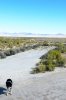
Kosmo was in the area of our vehicles
.jpg")
.jpg")
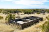
This had to be some type of large building. There are a lot of steel anchors in the concrete
.jpg")
One of the entrances to the dikes?
.jpg")
What appears to have been a loading platform for rail cars. You can just see the rail bed on the left of the pic
.jpg")
No idea what this was, there is a lot of concrete in it.
.jpg")
Looking west down the Rail bed. This is the rail bed for the Transcontinental Railroad. It went right through the town of Kosmo
.jpg")
County, Box Elder, Utah
Years of Occupation: 1901 - ? Perhaps someone else knows?
Status of Site: Open
Classification: Class 1,
Type: Mining - Railroad spur
Remnants: Foundations
GPS Coordinates: N41.71772 W112.79149
NRHP Reference #: N/A
Date of Last Visit: 10/14/17
Kosmo sometimes spelled Cosmo was built in two parts, the east part was built in 1901 as a rail spur for the growing number of ranchers in the area. The west part, (about a half mile away) was built in 1912 as a spur for Potash mining. Both areas were serviced by the Transcontinental rail line.
At that time potash was used in the manufacture of gun powder. Prior to this time most potash came from Germany but with the approach of world war 1, potash became difficult to acquire. Mining pot ash from the Great Salt Lake proved to be very profitable and west Kosmo was born. Around 1924 over 200 people lived in Kosmo.
The town contained 3 bunk houses, a cook house, garages, a General Store, a Blacksmith Shop, and several coal houses. Today not much remains, a few foundations, what appears to have been some type of loading dock and if you look southward you can still see some of the dykes and canals that were used.
Directions to Get There:
Take the most north Brigham City exit and head west past Corrine, toward ATK, (used to be Thiokol), turn toward the Golden spike monument museum. When you get to the last turn for the Museum, do not turn, head west several miles. There is not a sign for the town location, you best bet is to have a GPS. The town was/is located on the north/east end of the Great Salt Lake.
Or head to Snowville and turn south off of the Freeway. When you get to the locomotive springs sign, turn left and go east for 2 miles.
Modern Pictures:
Kosmo was in the area of our vehicles
This had to be some type of large building. There are a lot of steel anchors in the concrete
One of the entrances to the dikes?
What appears to have been a loading platform for rail cars. You can just see the rail bed on the left of the pic
No idea what this was, there is a lot of concrete in it.
Looking west down the Rail bed. This is the rail bed for the Transcontinental Railroad. It went right through the town of Kosmo